
Technology to save ecosystems: how Chile's Lemu satellite works
The Chilean satellite Lemu Nge, launched in 2024 on a SpaceX Falcon 9, is the world's first biodiversity satellite. Equipped with a hyperspectral camera, it allows ecosystems to be observed with a level of detail impossible for the human eye — and turns that data into actionable intelligence through Atlas, a platform that integrates water, carbon, vegetation, biodiversity, and human development.
This technology aims to transform conservation and demonstrate that caring for nature is also a smart economic decision. From Chile, Lemu monitors ecosystems globally to drive protected areas and a new model of development.
A report by Carlos Alberto López.
The most lush forest and the most arid desert on the planet. Ecosystems teeming with life — but how much do we actually know about this extraordinary biodiversity? Can technology help us gather reliable data about these landscapes?
Despite having more than 10,000 satellites in orbit, virtually none of them have the tools to characterize nature.
So after a lot of research, I remember one day having breakfast with my wife and saying: “honey, it seems like there's a satellite missing, and it seems like nobody is launching it — so it seems like it's going to have to be us.”
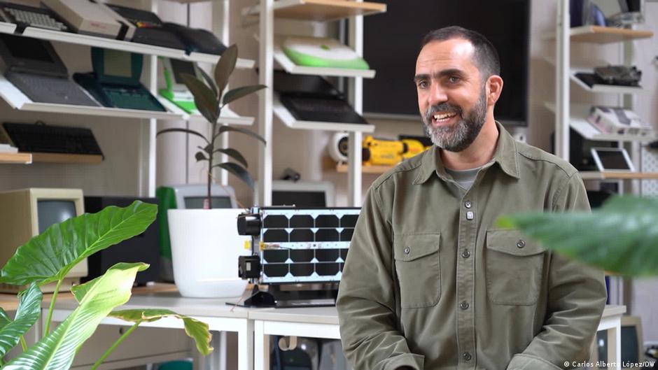
Self-taught, Leo Prieto began investigating how to build a satellite. What kind of camera should it have? Questions that, after much inquiry, he managed to answer.
We ended up reaching the most exotic laboratories — in Lithuania, in Beijing, in the most unexpected places — and finally assembling this global network of collaborators around one mission: to build the world's first biodiversity satellite.
In August 2024, the Lemu Nge nanosatellite was launched into space on a SpaceX Falcon 9. A device no bigger than a shoebox that orbits the Earth daily from pole to pole, north to south.
The great strength of our spacecraft is its camera. It’s a hyperspectral camera — which means, in simple terms, that it can see more colors, more light, than humans can. And that means we can see and distinguish things that traditional cameras, and our own eyes, cannot.
But it's not just about capturing images. The key is in how that data is processed and turned into information.
Out of everything we do, Lemu Nge — which means “Forest Eye” in Mapudungún — is what draws the most attention. But it's not the core of our solution. The core is Atlas.
Atlas is a nature intelligence platform. Imagine Google Maps, but instead of streets and shops and things that matter to humans, there are species and ecosystems — everything relevant about nature.
What our clients do is use Atlas to access multiple dimensions of nature: water, biodiversity, carbon, vegetation, air quality, human development.
In agriculture and forestry, they use our data to protect natural ecosystems and native biodiversity — because they realized that, even though the business is in their crops and plantations, taking care of the surrounding natural ecosystems reduces the risk of fire, drought, and pests. Working in balance with nature is a business decision.
What we want to achieve is to amplify the financial resources flowing toward effective conservation — and to do this by changing the way we see the relationship between ecology and economy: that they are one and the same, and that the economy needs nature to keep delivering the growth and quality of life we all expect.
Many people ask us: why aren’t you in Silicon Valley, why not New York, London, Tokyo, to launch satellites? And I say: we are exactly where we need to be.
We are in Frutillar, surrounded by pristine ecosystems that teach us a great deal — but we’re also in a country organized from north to south. Lemu Nge has a polar orbit — pole to pole — and so we have this perfect natural laboratory along our 4,000 kilometers, allowing us to study every type of ecosystem: from the arid zones to the wetlands of the Chilean altiplano, along with many other ecosystems that Lemu has set out to protect with cutting-edge technology.