
Frutillar, Chile — 11 February 2026 — Lemu today announced a new set of operational milestones for Lemu Nge, the world’s first biodiversity-focused hyperspectral nanosatellite. Between 29 November 2025 and 7 January 2026, Lemu Nge completed four successful customer taskings for Codelco, demonstrating both rapid turnaround and consistent monitoring over time.
Key Takeaways (TL;DR)
- First industrial tasking, end-to-end: On 29 Nov 2025 (Lemu Nge Session 1429, 10:54 AM local), Lemu Nge captured a flawless hyperspectral image of El Teniente and delivered it in under 4 days, proving customer tasking and delivery readiness.
- First three-month consecutive monitoring for a customer: El Teniente was captured three times across three consecutive months (29 Nov 2025, 18 Dec 2025, 6 Jan 2026), enabling a repeatable time series that makes change visible and comparable.
- Repeatability across sites, with real-world relevance: On 7 Jan 2026 (Session 1450, 10:55 AM local), Lemu Nge captured Gabriela Mistral, completing four successful tasking images and demonstrating how rapidly changing infrastructure and nature signals can be tracked — especially where coverage is lagging.
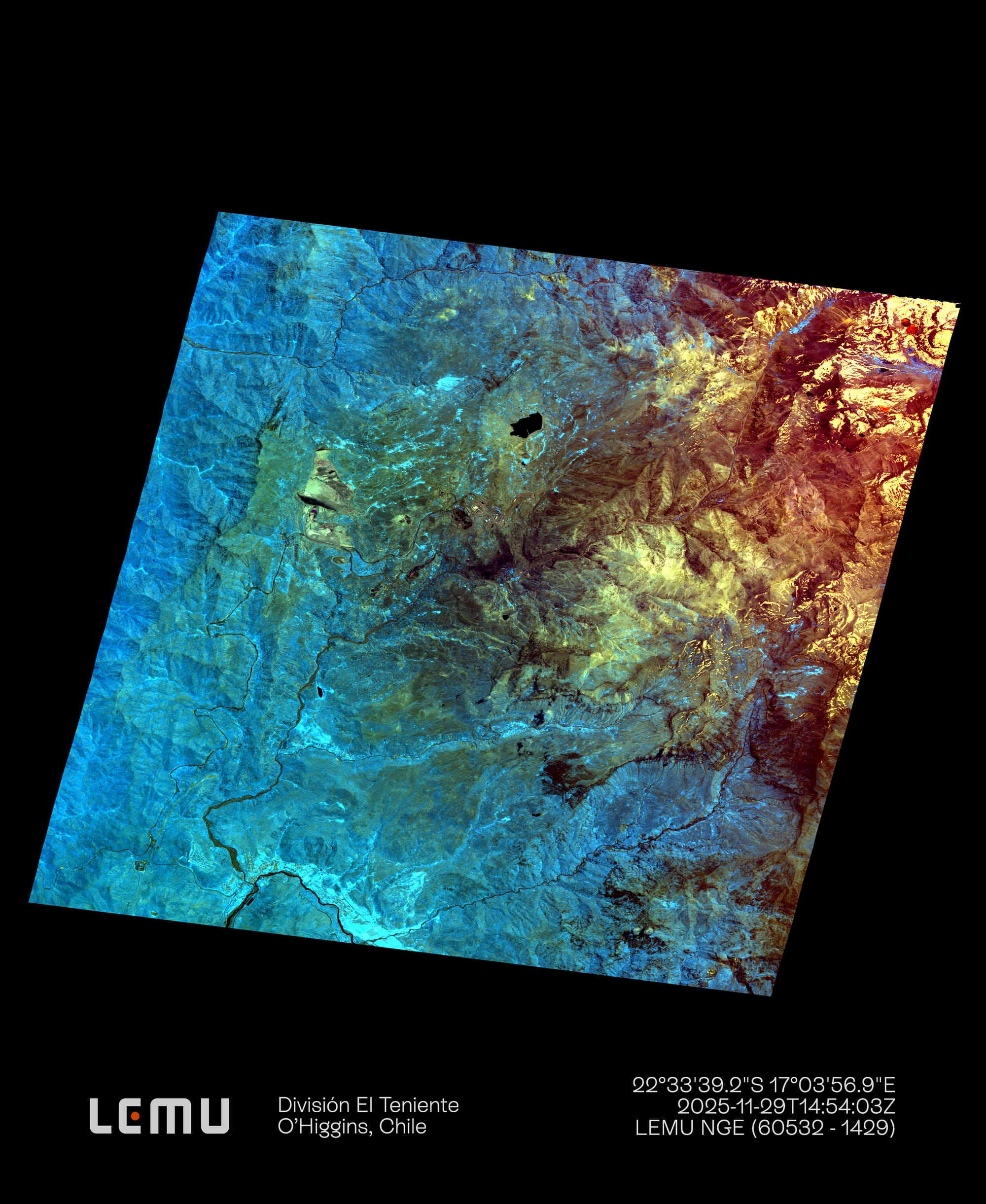
On 29 November 2025 at 10:54 AM local time (Session 1429), Lemu Nge captured a flawless hyperspectral image of Codelco’s El Teniente Division in Chile’s O’Higgins region. The image situates El Teniente within its broader living landscape — Andean slopes and ravines, and snowmelt waters flowing towards the Cachapoal river basin. In hyperspectral false colour, ochres help distinguish rock and exposed soils, while greens highlight vegetation and moisture — turning complex terrain into interpretable signals for long-term land and ecosystem management. The data product was delivered in less than four days from capture to delivery, marking Lemu’s first end-to-end industrial tasking.
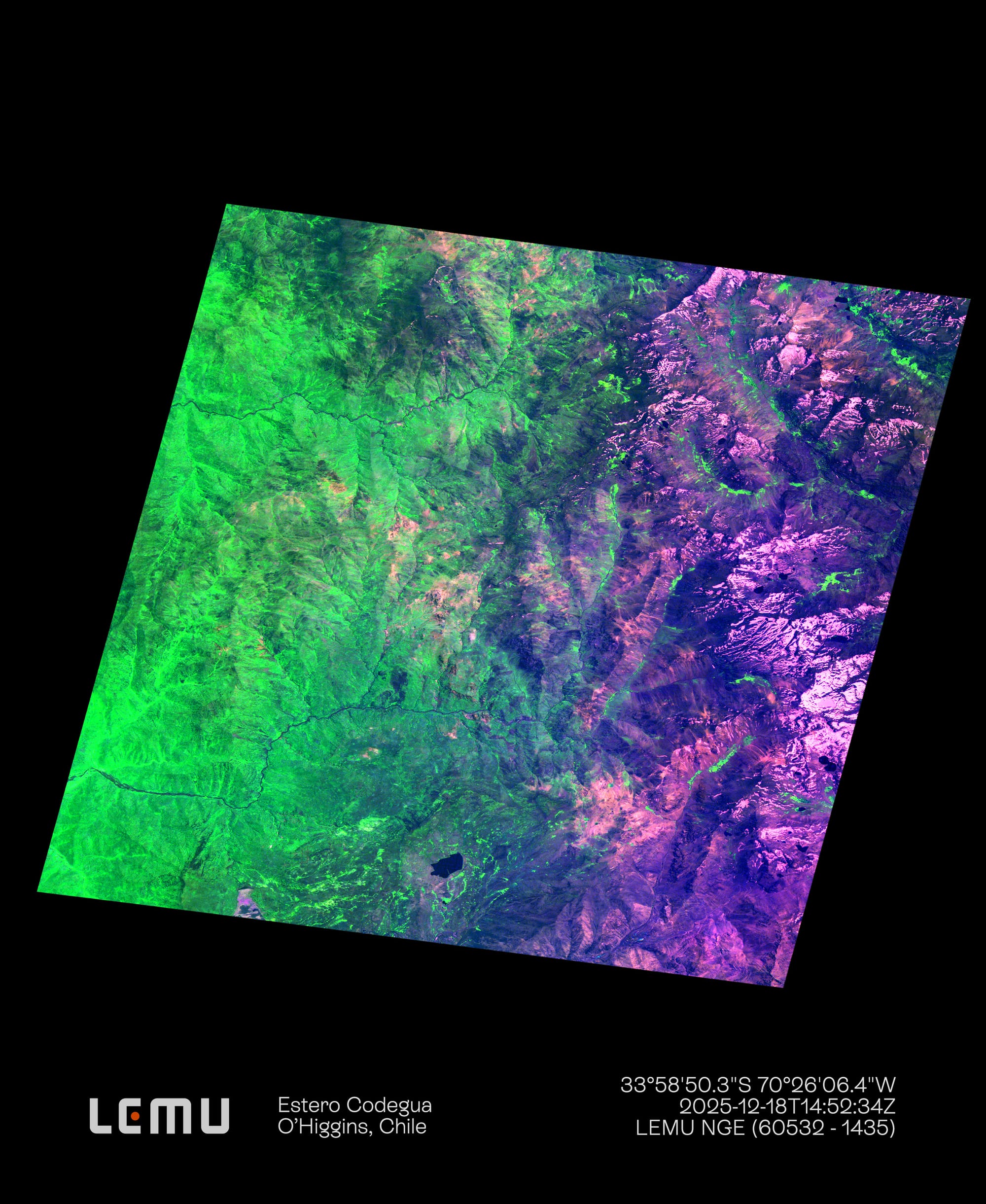
Lemu Nge then returned to the same Area of Interest to reach a second milestone: first customer monitoring across three consecutive months. Follow-on captures were completed on 18 December 2025 at 10:52 AM local (Session 1435) and 6 January 2026 (Session 1447), creating a three-image time series for one location. The second capture includes the headwaters of Estero Codegua (north of Caletones), the Río Peuco, and Cerro La Punta towards Pirque and the Metropolitan Region. In false colour, vegetation signals are emphasised — including characteristic sclerophyll species such as quillay and boldo — making the boundary between greener foothills and more exposed Andean terrain clearer to interpret.
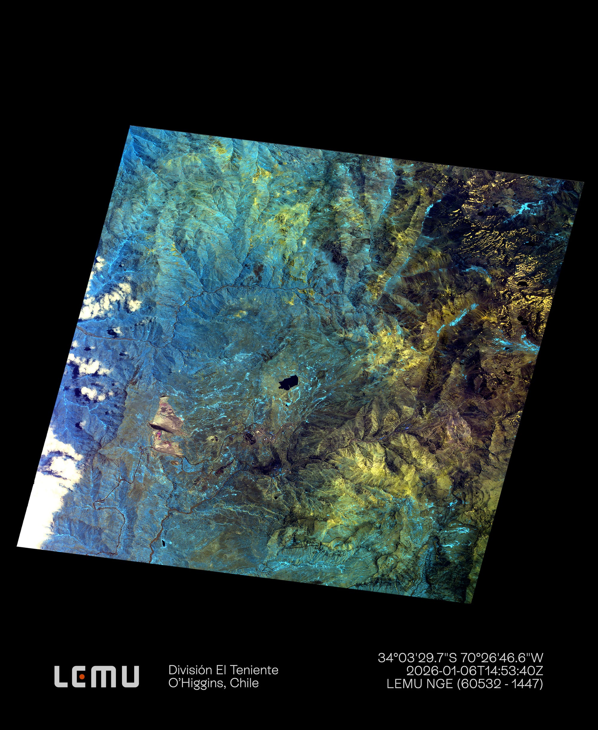
By the third capture (Session 1447), 38 days after the first observation, the value of monitoring over time becomes tangible: even across a short interval, the hyperspectral signal can show shifts in vegetation and runoff patterns in ravines, alongside areas of more exposed soil and rock. Around high-mountain landmarks such as Sewell, the imagery highlights the complexity of the surrounding mosaic — steep slopes, seasonal water courses, alluvial fans, and transitions across vegetation zones — reinforcing why time-series observation is essential for anticipating uncertainty, rather than reacting after the fact.
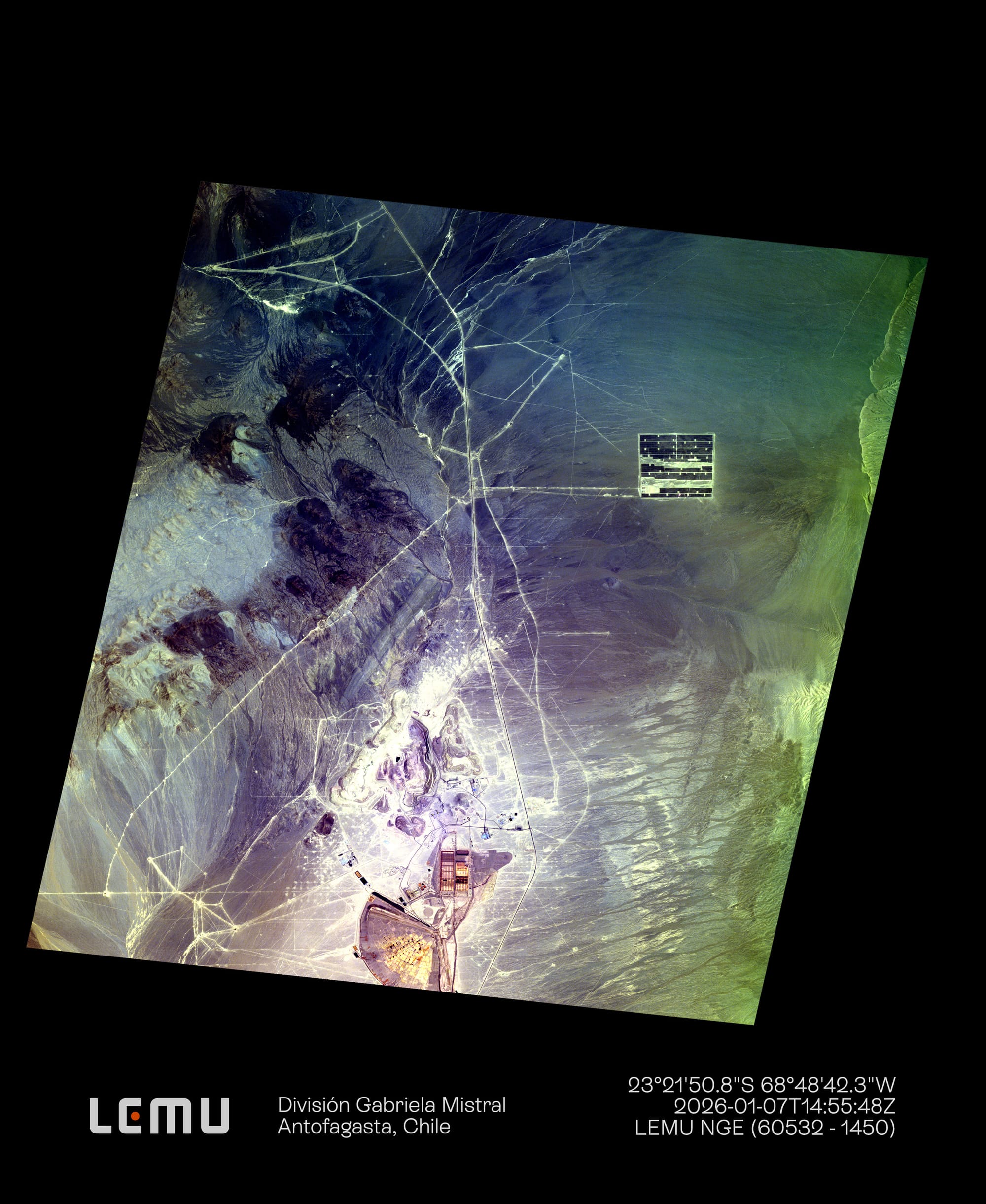
Finally, on 7 January 2026 at 10:55 AM local (Session 1450), Lemu Nge captured Codelco’s Gabriela Mistral Division in Antofagasta, successfully concluding four tasking images delivered for an industrial customer. The scene shows how fast the real world changes: new infrastructure is visible in the Atacama Desert, including a solar plant that was not yet reflected in mainstream consumer maps at the time of capture. Beyond the immediate milestone, the image reinforces a broader reality: the Southern Hemisphere remains underserved by frequent, high-resolution updating — precisely the gap Lemu Nge is designed to close.
“This is what operational looks like: tasking, capture, quality, delivery — smooth and steady — and then doing it again, consistently,” said Leo Prieto, CEO of Lemu. “Lemu Nge began as an R&D mission, but it keeps surpassing our expectations: it’s now delivering commercial-grade monitoring with the resolution that matters — spectral depth, spatial detail, and genuinely fresh information. When new infrastructure appears in our captures before it shows up on public maps, that’s a decision advantage.”
Milestones achieved
- Session 1429 — First industrial customer tasking completed: 29 November 2025, 10:54 AM local, El Teniente Division (O’Higgins, Chile). Flawless hyperspectral capture; landscape context includes snowmelt waters towards the Cachapoal basin; <4 days capture-to-delivery.
- Session 1435 — Second capture in the monitoring sequence: 18 December 2025, 10:52 AM local, El Teniente Division (O’Higgins, Chile). Includes Estero Codegua headwaters, Río Peuco, and Cerro La Punta, with vegetation signals (including quillay and boldo) made legible in false colour.
- Session 1447 — Third capture completing three consecutive months: 6 January 2026, 10:53 AM local, El Teniente Division (O’Higgins, Chile). 38 days after the first observation, change signals appear over time — including vegetation/runoff shifts in ravines and areas of more exposed soil/rock — reinforcing the value of time-series monitoring.
- Session 1450 — Fourth successful customer tasking delivered: 7 January 2026, 10:55 AM local. Gabriela Mistral Division (Antofagasta, Chile) — new Atacama infrastructure visible, including a solar plant not yet present in mainstream maps at the time of capture.
About Lemu Nge
Lemu Nge (“Forest Eye” in Mapudungun) is a 6U hyperspectral nanosatellite designed for biodiversity and ecosystem monitoring. It captures 32 hyperspectral bands (420–900 nm) with a ground sampling distance of under 5 metres, supporting repeatable observation of ecosystem dynamics over time.
About Lemu
Lemu is Latin America’s leading Nature Tech company, making nature visible in every decision. We build Atlas, a Nature Intelligence platform that transforms complex environmental data into clear, actionable insight. By combining AI, Earth observation, and ecological science, we bring Nature Intelligence to Business Intelligence — helping organisations understand their impact and dependence on nature, and protect the living systems we all depend on.